New Partnership Aims to Keep 2.4 Billion Gallons of Water Out of the Beef Supply Chain
Data is the missing link in building a reality-based, grower-centric, and scalable water stewardship plan.
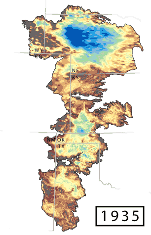
Saturated thickness snapshots
Data from Haacker et al. 2016; GIF by Lacey Moore via ogallalawater.org
As the morning sun beats down on the golden corn fields of Nebraska, growers all across the state start to mentally calculate their day ahead: driving to one field to turn on (or off) the irrigation pivot; maybe swinging by a tipping bucket to see how much rain actually fell overnight, if any; remarking to themselves that the next field over the hill and to the south usually seems to get more rain so may need less attention, but that squall receding on the western horizon could say otherwise today, better go and see.
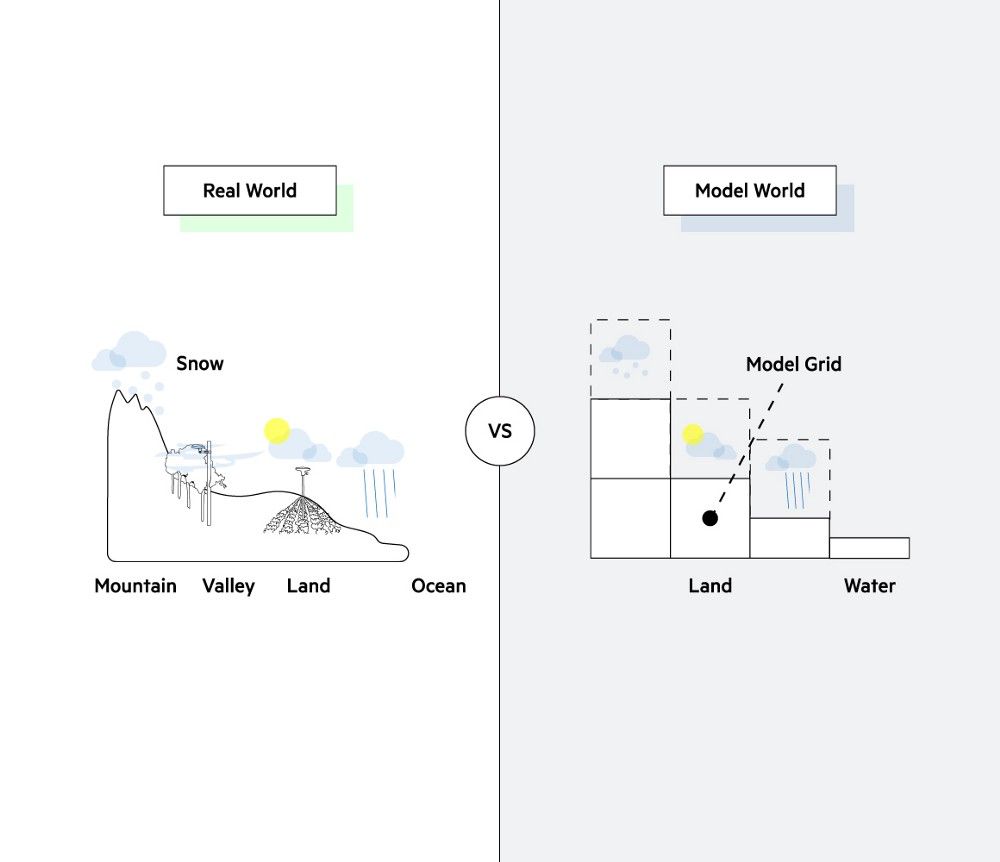
It’s a daily dance managing time, labor, fuel, water, and energy that exacts a mental load from growers and managers across the corn belt. Optimizing irrigation plans relative to yield goals is an inexact science, even with satellite weather data at our fingertips; out on the prairie, the nearest weather station may be miles away, and located on the tarmac of an airport whose microclimate is much different than a planted field. There’s also no definitive way to know, other than through years of experience and experimentation, how climatic factors like weather and rainfall actually — precisely — affect inputs, expenses, crop quality, and yield.
Or is there?
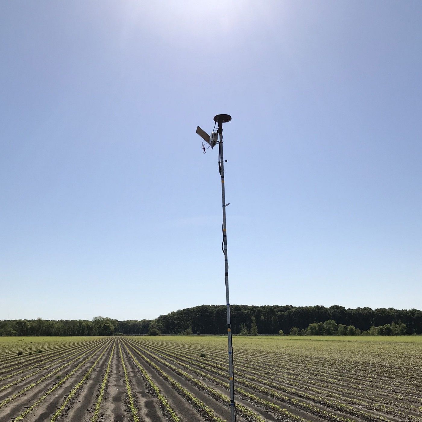
The Arable Mark high above a just-planted Nebraska cornfield this spring.
To address this issue, Arable has entered a three-year water sustainability initiative. centered on reducing water pumped from the Ogallala Aquifer to irrigate the agricultural fields above it. Since widespread irrigation began in the 1950s, about 9% of the total recoverable reserve has been pumped out, to varying degrees by state and year, largely dependent on local weather patterns. Knowing more about how these weather patterns play out can go a long way towards reducing the need to irrigate, which will lessen costs to growers and lower nutrient runoff downstream.
In 2016, a group of corporations across the American food production, distribution, and retail spectrum aligned with conservation organizations to identify and reproduce ways to mitigate the environmental impact of the agricultural supply chain, with a focus on air, soil, and watershed stewardship in three pilot states: Illinois, Iowa, and Nebraska. The idea of a cross-border coalition makes sense in the context of environmental protection, since the effects of unchecked emissions, erosion, and runoff extend far beyond the jurisdictions in which they originate. Illinois and Iowa share a border defined by the Mississippi River, which drains into the Gulf of Mexico, and Nebraska lies almost entirely atop the vast Ogallala Aquifer, which feeds eight states. Out of this grew our project with the hope to scale up success from the 50 participating Nebraska farms — spread over 75,000 acres — to the entire region, and perhaps even take lessons learned global.
A top-down initiative such as this has unique potential to support growers in doing what they do best: innovate. Farmers are the ones with boots on the ground and hands in the dirt; the last few millennia of human progress rest on a scaffold of agricultural ingenuity born out in the field. As a result, our modern food system is so intricately embedded in a global supply chain that it can be easy to lose sight of the significance one farmer can have as a change agent within the larger web, and overwhelming to take that next step out of one’s comfort zone to define and adapt to new norms.
Meanwhile, large agribusinesses have the power to lobby lawmakers on behalf of their growers and initiate change on a scale that is all but impossible on an individual level. And doing so within a framework laid out by conservation partner organizations lends an important credibility to the project, ensuring that lower costs, higher yields, and farmer livelihoods don’t come at the expense of environmental wellbeing.
Just a few of the ways the Mark gathers data.
Arable provides the pioneering technology that will help growers connect the dots between decisions and outcomes. Reaching tangible milestones is about more than a desire to do better; you have to be able to measure better, and to make confident choces borne out by the data collected. To do so, the Arable Mark’s IoT device captures over 40 data streams. Several metrics are especially important to growers in the High Plains watershed; let’s take a closer look at some of these.
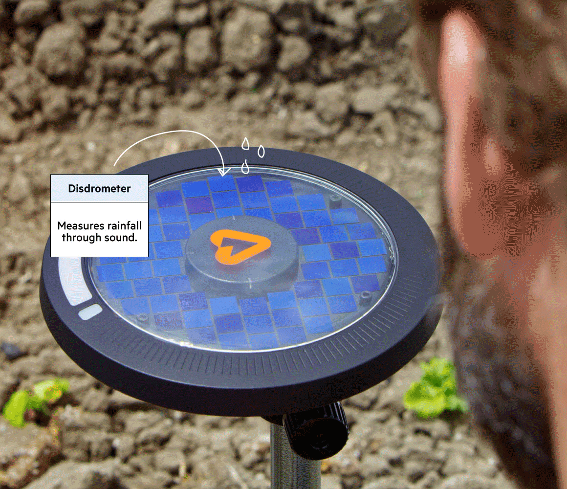
Precipitation: Know How Much It Rained

When it rains, the dome of the Mark acts as a drumhead, part of a patented acoustic disdrometer that measures the sound of precipitation as it falls on the device. An algorithm then processes this information, determining both the amount and size of the drops to ascertain average rainfall over a given period of time, to a demonstrated accuracy of within 0.2mm/hr. Because rain is wildly variable over time and space, this kind of ground truth is a vital element to any decision-making process. Gone are the days of traveling out (in rainy weather, no less) to check on tipping buckets in muddy fields. Read more about precision ag weather data.
Arable Point and Weather Forecasting: Know When More Rain Is Coming (Or Not)
Precipitation measurements are continually synthesized with publicly available weather data, resulting in 10-day, field-specific forecasts generated by our patented Point technology. Growers can access through one device more granular and relevant information — specifically on precise field temperature, an indicator of crop water stress — than any existing weather station can provide.
Evapotranspiration & Dynamic Crop Coefficient: Know Your Water Budget

On top of climate measurements, the Mark also takes a series of hourly and daily radiation measurements, then uses these as part of an equation to calculate the rate of evapotranspiration (ET). Arable specifically measures ETc, or the ET of the crops in the field. Including dynamic crop coefficient measurements taken from the growing (or wilting) canopy directly below the device tells us about the water stress levels of the plants and adds a ground-truth dimension to the ET calculation that can only be obtained through in-field measurements. This information, combined with known and projected precipitation from Arable Point, tells the grower exactly how much water to pump (or withhold) to get a desired outcome. Armed with precise calculations, a savvy manager can devise a plan to not only keep a crop watered and healthy, but manipulate quality through deficit irrigation and targeted water stress levels. Read more about how Arable calculates ET.
Chlorophyll Content: Know Your Plants’ Pith and Vigor

Another measurement vital to monitoring the health of Midwestern row crops is light on the visible spectrum, and for this we use a spectrometer. By recording light from the sky and the reflected color of the leaves below, in increments invisible to the human eye, the Mark monitors the plants’ chlorophyll content. The resulting chlorophyll index is a proxy for plant productivity and nutrient content, which impacts decision-making around irrigation and fertilizer use. Even with an optimal irrigation plan based on observed field conditions, without watching the actual plants’ behavior, you could fall short of your targets. A diseased plant may not be able to access the water and nutrients you provide, so it’s important to know exactly how inputs affect the plants’ output. Having all of this information available in one device eliminates the guesswork. Many farmers also employ remote sensing tools like satellites and drones to measure vegetation indices, but only an in-field device can provide continuous, actionable granularity without interference from clouds, pollution, or dark of night, and connect it to all the other measurements outlined here. Read more about remote sensing tools.
Why Does It Matter?
These metrics combine to give growers an unprecedented, real-time snapshot of how the irrigation plan they based on measured precipitation and ETc affects the vitality of the plants, and thus the quality and yield of the final product. In addition, a grower’s confidence in exactly how much rain is expected achieves the overall goal of watering crops only as much as they need, saving them time visiting far-flung fields, energy in fuel costs, and money on inputs that may have otherwise been washed away by excess water.. Having just one device in the field to capture a dependable water budget in its entirety is an invaluable tool in widening one’s profitability and productivity margins while maintaining the value of the land, water, and air around us.
The Mark is the only device to combine all this weather and plant data in one, providing demonstrable evidence on which decisions made earlier in the season lead to specific outcomes later, with reverberations throughout the supply chain, from the local grower to the global brand. The farmers of 2018 make choices rooted in generations of shared knowledge, innovations on the field, and real data at their fingertips. Arable’s goal is to capture and relay the information that empowers them to assess their own field management strategies and adapt on the go to solve micro problems on a macro scale.
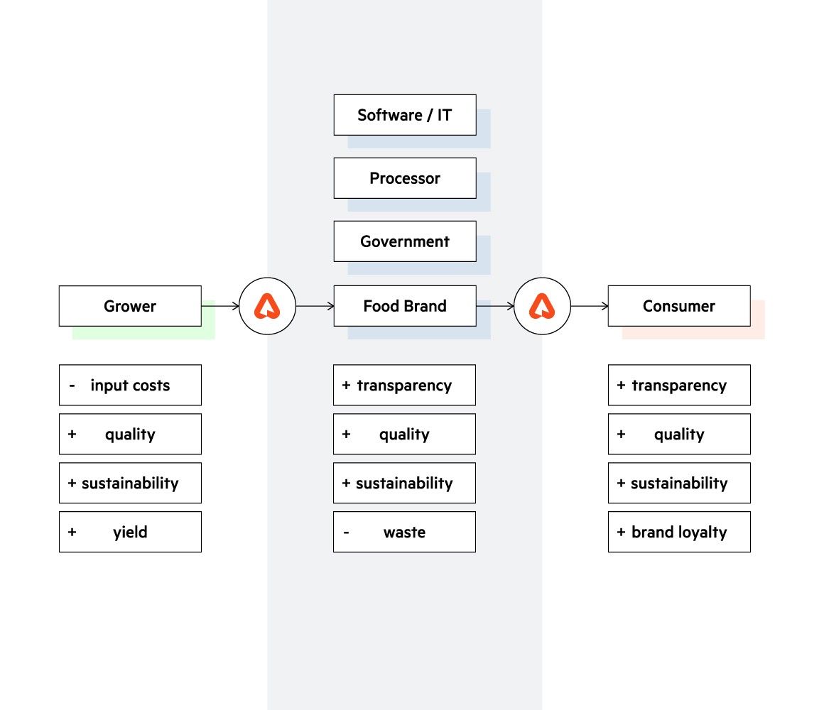
Data benefits up and down the supply chain.
By partnering with conservation organizations on intiatives like these, industry giants are ushering in a new era of corporate responsibility in agribusiness. Arable’s role as a conduit of information and analytics helps keep this transformation reality-based, grower-centric, and replicable on a regional or global scale. The Arable platform is affordable, easy to install right out of the box, and highly integratable, using the Arable Bridge to connect to existing field devices such as soil moisture probes, flow meters, wind speed monitors, and more. Our data is accessible through an intuitive app interface, downloadable CSV reports, or our API. Each of these is a path for users to interact with their data in a way that works for them, whether growers, managers, insurers, salespeople, agtech firms, researchers, nonprofits, or international agribusinesses.
After the three-year program is up, participating growers have the option to continue using the technology in their operations. Our hope is that the data gathered can be used as tools by those who anchor the agricultural supply chain to discover and address obstacles in their operations, empowering them to devise unique solutions to specific — yet also very likely universal — problems. Water issues, from irrigation plans and rainwater management to runoff and resource preservation, are a major frontier in agriculture today, and partnerships like ours are an important step in addressing them.
For more information about the Nebraska irrigation partnership, click here.
To learn more about Arable, please visit our web site.