Remote Sensing is so . . . Remote
The gap between satellites and the crops they measure.
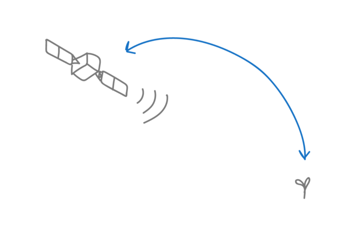
Much of precision agriculture is focused on sizing up the damage after it’s already happened. There is a proliferation of imagery being used in precision agriculture from brute-force imaging by TerrAvion to elegant machine learning of satellite imagery by Descartes Labs. While people do amazing things with satellite images (see tomnod.com or Matt Hansen or dig into the CORONA program), it is for the most part pretty pictures in the rear view mirror, reflections of the way life used to be.
What can you do with these images by the time you get them? Tracy Blackmer, a senior agronomist at FarmLogs, gives a great talk on diagnosing field problems with airborne images: a trained eye can distinguish a plugged seeder, a lazy manure spreader, a double-spray of herbicide, but short of firing your manure applicator or repairing the planter, there isn’t much you can do about these problems.
The farmers I know spend a lot of time in the truck, out in their fields, hoping to spot problems before they get big, and taking action to make them better. When I studied weed science, we learned to identify a species by its cotyledons (the first two leaves) because anything beyond that and you’re too late to spray, and the damage has been done. Professional agriculture is about being proactive not reactive. As my friend who works as a Certified Crop Advisor says, “the crop plan is not reality.” Successful farmers are searching to identify any deviation from the plan, so they can be agile in responding.
We are paving the future at Arable by taking the best part about satellites — the ability to measure the state of the growing plants — and combining it with the physical drivers that make plants grow. For decades, farmers had tools enabling the spatial integration of information — to measure yield coming off the whole field, or to map leaf area by NDVI across an entire landscape. But now, for the first time, farmers have a tool to integrate that data in time: the accumulation of sunlight and heat and how those have translated into crop growth; the time spent with condensation on leaves and how that increases disease pressure or reduces shelf life; the integrated crop water deficit that determines how much to irrigate (and how long a field was actually irrigated); the time spent under mild water stress and how that translates into better fruit quality.
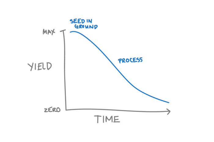
Satellite Imagery (and most of Precision Agriculture as we’ve come to know it) is most useful for that period after harvest when you’re making plans for next year: budgeting out the crop plan. Buying seeds and firing your manure applicator. The Pulsepod is what you want during the season when you’re making plans on how to allocate time. The moment before a seed is planted, it has the greatest yield potential of all, and every moment after that, yield potential is lost. It is the timely decisions made during the season that protect potential yield against risks, as they unfold.
A few companies like Mavrx, Ceres Imaging and Hydrobio are stepping into the fray with time series of multispectral imagery, which offers some advantages over the once-a-year yield map or occasional soil map, and even the couple-a-season satellite maps. These are powerful tools and I am sure they will deliver value to growers. Descartes Labs is making a great leap with machine learning on mammoth datasets to make national scale corn forecasts for commodity brokers and agribusiness giants. But it’s worth taking a moment to reflect on what remote sensing tools will never be able to provide.
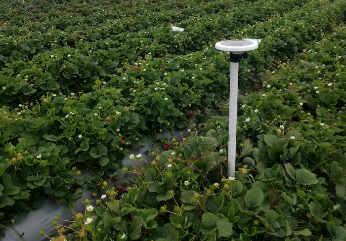
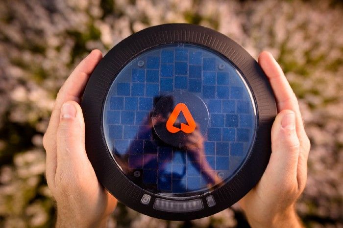
Arable’s Pulsepod
Measures weather in the field. The Pulsepod is immediately there in the field measuring microclimate, crop status, rainfall, when it is sunny and when it is cloudy, when the sun is shining and when it’s not. You get the granularity and accuracy of a measurement made right next to your crop, not from space. We also measure under hoop houses and in the shade where satellites can’t get to.
Measures all the time. You get continuous, real-time data so you don’t miss a beat of your crop’s growth The growers we know take a single airplane measurement mid-season to see if there are any spots that require attention. Some airplane providers are providing monthly maps. Neither of these options are ideal for making important decisions during the year, as processes are actually unfolding.
Integrates with measuring equipment. We work with your existing infrastructure so you can, for example, sync up crop water demand with water actually applied by irrigation. Measure soil moisture or fruit size or well depth? We can integrate with that gear too.
Can take hi-res pictures. Watch fruit grow, scout for pests, look for conditions of disease, in response to the actual microclimate that happened. These let you gain predictability in how biology is happening in the field for integrated pest management or forecasting fruit and vegetable yields.
Measures multiple spectral bands. If you think existing satellites provide these, or that Planet Labs will eventually send up a constellation, think again. For sure, some new airborne imaging companies are taking advantage of the decades of research (from my old lab, among others) that show that plant pigments (like chlorophyll), water content, biomass, and even soil type can be revealed by multi- and hyper-spectral imagery. But the real opportunities from understanding your plants at this level are in the relationship between growth and nutrient uptake and water status relative to microclimate and management over time: understanding process and mechanism, not just pattern.
Measures ground truth. In the distance between the crop and space, satellites pick up a cacophony of noise. None of this has to do with the plants themselves, it’s just irrelevant noise that prevents images from being directly compared over time. It’s not generally appreciated that satellites and aircraft don’t measure “reflectance,” the actual ratio of radiation coming up in all directions, to radiation coming down from all directions. That ratio is important: without it, the image looks bright, or dark, depending on the time of day, the solar angle, the view angle, or clouds or aerosols in the sky. The good news is that the Pulsepod measures actual hemispherical reflectance, with identical daily view and sun angles for consistent interpretation. Better yet, by using the exact sub-centimeter GPS coordinates on the Pulsepod, plane and drone operators can correct their imagery for ambient illumination and view conditions, and register the images to a common coordinate system to pull more information out of those images.
Empowers people on the ground. Farming is the last place a computer is ever going to take jobs away from people, because there is no environment that requires more from the insights and experience from the people in the field. Obviously people are planting the seeds and adding the fertilizers and spraying for bugs, and algorithms don’t do a lot of good if they don’t know what the basic operations are. Don’t forget that those agribusiness giants have to send people out with rulers measuring corn to develop their forecasts, and Descartes would be nowhere if the USDA didn’t survey the farmers on their yield outcomes. The larger challenge with remote sensing is that it is detached from the human dimension of agriculture.
The problem with remote sensing is in the name. It is SO remote. Without sensors in the field and boots on the ground, the gap between the cause (weather, treatment, etc.) and effect (crop stress, berry ripening) of your crop growth is too great. At Arable, we understand the critical timeframe for action, and provide the measurements that matter to empower decision-making in moments that matter. Step aside precision agriculture.
It’s time for decision agriculture.italic text
Learn more about Arable here.